|
Light Rail Now/Light Rail Progress can be contacted at: Light Rail Now! |
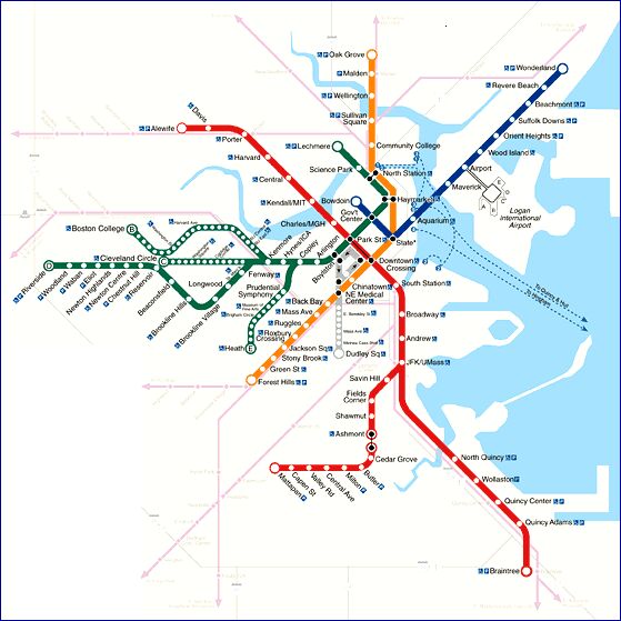
Boston has several important light rail transit (LRT) lines within a network of both light and "heavy" rail rapid transit and regional "commuter" rail lines operated by the Massachusetts Bay Transportation Authority (MBTA – see map below). The MBTA's rail routes are color-coded, with three full metro lines (Red, Orange, and Blue), and with most of the LRT routes grouped into the Green Line. in addition, one of the Red lines, Mattapan-Ashmont, is an important supplementary connector route operated as LRT on a former railway surface alignment.
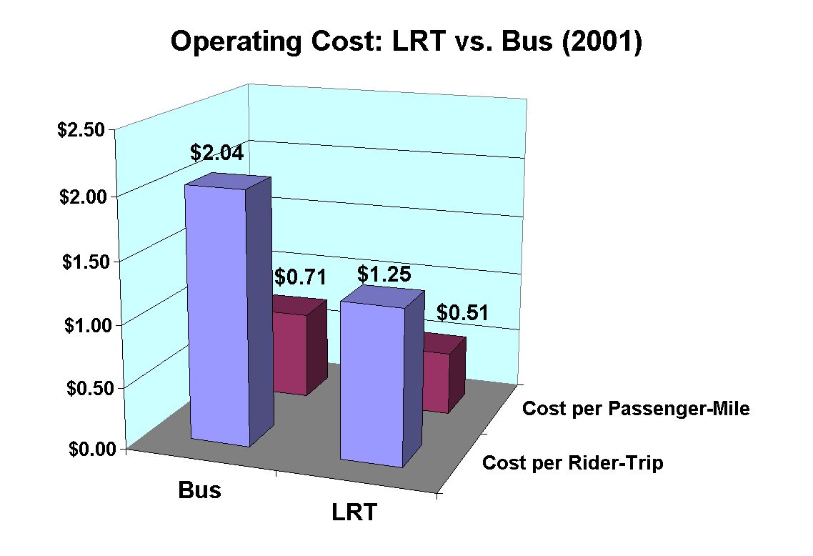
Boston's LRT services currently carry the heaviest LRT ridership in the USA. Furthermore, in unit operating cost, LRT is significantly less costly than bus services. According to the Federal Transit Administration's 2001 National Transit Database, the MBTA's LRT system carried passengers at an average cost of $1.25 per trip, and $0.51 per passenger mile, compared with MBTA average bus costs of $2.04 per trip and $0.71 per passenger-mile. (See graph below.)
Green Line LRT Services The Green Line, quite similar in concept to San Francisco's Muni Metro, has four branches which run underground in the Boston CBD (actually, this is America's oldest subway, opened in 1897), and at street level, mostly in median reservations, with numerous level crossings at intersections. As with the Muni system, Boston's Green Line is the remaining vestige of the city's once-vast surface railway (streetcar) network.
The Green Line system consists of about 25.4 miles (41.0 km) of route, of which 5.0 miles (8.0 km) are underground, and 1.3 miles (2.1 km) are elevated. There are some 70 stations/stops along all the routes of the Green Line system, and well over 200 light rail vehicles (LRVs) are operated. The Green Line system currently has 4 branches, designated by route letters, and with terminal points as follows: * B Boston College to Government Center (Commonwealth Ave.) * C Cleveland Circle to Government Center (Beacon St.) * D Riverside to Lechmere (Highland Branch) * E Heath Street to Lechmere (Huntington Ave.) The system extends from a terminal at Lechmere in east Cambridge, across the Charles River Dam on the only continuously operating trolley viaduct that is still in use today. From there the tracks are lifted above the local streets on the last elevated in Boston. This El is quite unique, being designed specifically for trolleys, twisting around Boston's (heavy regional and intercity railway) North Station and into the central LRT subway through downtown. Heading westward, the subway runs through Boston's Back Bay section, with several routes diverging into different branches, as indicated above, and described below. The E Line branches southwest toward Huntington Avenue, exiting the subway near Northeastern. E Line LRT trains then run in a street median to Brigham Circle. From there the line operates in street pavement to Heath. This is currently the only MBTA LRT line with street running in mixed traffic. The central subway trunk route continues west to Brookline, where it then splits into three more branches fanning out westward: The B Line branches off to run down Commonwealth Avenue mainly in a median reservation alignment, providing a rather slow, stop-and-go ride from the tunnel portal near Brookline all the way to Boston College. The C Line, branching out of the subway, then operates on a nicely landscaped median down Beacon Street in Brookline, terminating at Cleveland Circle. This route has maintained nonstop trolley service for over a century. The D Line "fans" off the tunnel trunk route at Brookline. Relatively the "newest" branch, this line follows an old Boston and Albany Railroad commuter railway route that was converted to rapid transit in the late 1950s, and represents one of the earliest North American implementations of the LRT rapid transit concept in the post-World War Two period. The route provides a quite fast and scenic ride all the way to Riverside on an exclusive right-of-way. Many of the old commuter railway stations are still intact and even continue in use as LRT stops. A large storage yard and maintenance shop are located at Riverside. Operations on the C, E, and B lines interact with street signals and traffic along each route. The Green Line system is extremely busy with heavy passenger traffic, carrying more than 230,000 daily rider-trips. Red Line LRT Service
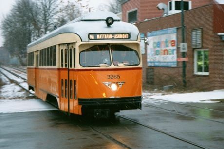
This route, the single vestige of a once-extensive array of trolley lines which fanned out from Ashmont, operates on an exclusive right of way and has two crossings at grade. The High Speed Trolley Line goes right through a cemetery at Cedar Grove – the only Boston-area rail alignment to do so. The service currently carries about 7,000 rider-trips a day. Other Boston-area rail transit Boston's LRT system is a critical link within the metro area's extensive network of "heavy" rapid and regional rail transit lines, which carry the bulk of Boston-area rail transit ridership. A brief review of these additional rail transit services will be useful to a full understanding of rail transit in the area. Red Line
The Braintree Branch runs along former New Haven Railroad
right-of-way from Braintree, through Quincy, to a junction with the
Ashmont line. The route features a trip through open cuts, on
elevated embankments, over a large bridge over the Neponset
River, and over another flyover in Dorchester before meeting up
with the Ashmont Line. There the two lines merge and dive into a
1920s-era tunnel. The merger of the two lines is also unique as it
involves a series of tunnels and flyovers that allow trains to merge
from the two branches without blocking each other's path. Orange Line
The line runs from Malden at Oak Grove on a surface right-of-way along a former Boston and Maine commuter railway route. The northern segment is routed in a series of depressions, elevated embankments, a bridge over the Mystic River, and a passage under I-93 to a tunnel under the Charles River. From the tunnel, through downtown, the line turns south and west, then emerging along the Southwest Corridor. The rest of the route is in a retained cut all the way to through Jamaica Plain, Roxbury, and on to Forest Hills along the Southwest Corridor – the newest section of the Orange Line from Chinatown southward. This section is the subject of a controversy that has evolved into a heated political conflict. The Orange Line was formerly routed on an elevated structure over Washington Street, parallel to the Southwest Corridor, to Forest Hills. In 1987 the Washington Street El was dismantled when the MBTA opened the Southwest Corridor, providing more stops, and faster service, than the El. However, residents along Washington Street were not pleased, as the move left them with no rapid transit alternatives. The MBTA suggested a light rail extension of the Green Line as a replacement (apparently also, less prominently, hinting of a dedicated bus lane as another alternative). The bus lane, reborn as "Bus Rapid Transit" or "BRT", has been the MBTA's "solution", designated the Silver Line (or "Silver Lie" as it is derisively called by Washington St. community activists, who feel the MBTA has reneged on a promise of real rapid transit). Blue Line
The line operates from Bowdoin Station in downtown Boston eastward, then northeast to Wonderland in Revere. The route is in a subway until reaching the Airport station in East Boston. From that point it is on the surface, except one short tunnel in east Boston which separates the alignment from a Boston and Maine Railroad spur which crosses the route path. While in subway, power is collected from a conventional third rail. However, power collection switches to an overhead contact system (OCS) on the surface, with a switch in current collection usually made at either the Airport or Maverick. The Blue Line operates particularly short cars, because of close clearances within the alignment, some of which was a former streetcar line. Purple Line Regional ("Commuter") Rail Boston's MBTA operates an extensive and expanding regional ("commuter") rail network throughout the urban area. The regional rail network has continued to grow since the 1980s with new lines and more service being added. The network radiates out of Boston from North and South Stations, with track mileage totalling over 200 miles (300 km).
The regional rail network has evolved from former commuter trains operated by the Boston and Maine, New Haven, and Boston and Albany Railroads. As private automobile travel, promoted and assisted with heavy government subsidies, began to make inroads on the regional rail network, service cutbacks began to grow. One of the biggest occurred when the Southeast Expressway opened, spelling the end of service on the Old Colony routes on the south shore. As freight railroads began to get out of the passenger business, the newly created MBTA began to oversee and help fund Boston's regional rail network. While at first, particularly in the 1970s, the situation looked bleak, by the 1980s traffic congestion was intensifying dramatically, and more people began to ride the regional trains. At the same time the MBTA was increasingly successful in procuring funding for improvements, including new equipment. Eventually new lines were opened, routes were expanded, and service was increased Even on the Old Colony line, where no rail service had existed since 1959, service was restored in 1997. Today the regional rail network continues to grow, as does the ridership. This report has included material adapted from information on the MBTA RailFan wepage, the MetroPlanet website, and the MBTA. Data have come from these sources as well as the FTA NTDB. Boston rail map: MBTA. Updated 2003/05/28 |
 While the Red Line is primarily a "heavy"
fully grade-separated, rail rapid transit line,
a quite unique and special LRT branch of
the Red Line also exists – the
While the Red Line is primarily a "heavy"
fully grade-separated, rail rapid transit line,
a quite unique and special LRT branch of
the Red Line also exists – the 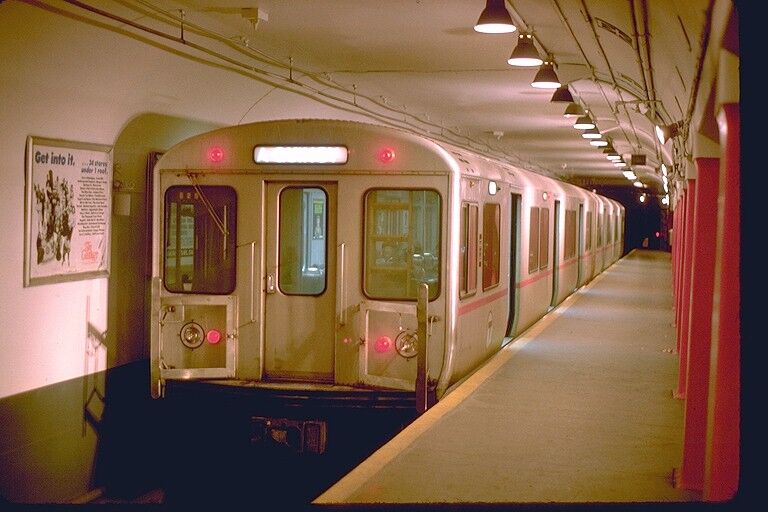 The Red Line is the longest of the MBTA's
"heavy" rapid transit routes, operating with
two branches totalling 20.5 miles (33.1 km,
excluding the 2.6-mile Ashmont-Mattapan
LRT line), with about 8.7 miles (14.0 km)
underground, and 22 stations. The oldest
and original route is the Ashmont Line,
serving Dorchester and then curving its way north and east to a
junction with the South Shore route in South Bay. The route is in a
subway from Ashmont to approximately the vicinity of Fields
Corner. From there it is routed on an elevated embankment right-of-way and in a surface alignment to a junction with the South
Shore Line.
The Red Line is the longest of the MBTA's
"heavy" rapid transit routes, operating with
two branches totalling 20.5 miles (33.1 km,
excluding the 2.6-mile Ashmont-Mattapan
LRT line), with about 8.7 miles (14.0 km)
underground, and 22 stations. The oldest
and original route is the Ashmont Line,
serving Dorchester and then curving its way north and east to a
junction with the South Shore route in South Bay. The route is in a
subway from Ashmont to approximately the vicinity of Fields
Corner. From there it is routed on an elevated embankment right-of-way and in a surface alignment to a junction with the South
Shore Line.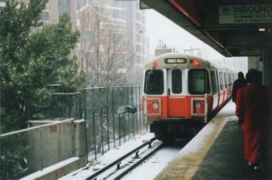 The Orange Line totals 11.1 miles (6.9
km), with 1.9 miles (3.0 km) in tunnel, 4.6
miles (7.5 km) elevated, and 22 stations.
End-to-end running time is 33 minutes,
producing an average schedule speed of
20.2 mph.
The Orange Line totals 11.1 miles (6.9
km), with 1.9 miles (3.0 km) in tunnel, 4.6
miles (7.5 km) elevated, and 22 stations.
End-to-end running time is 33 minutes,
producing an average schedule speed of
20.2 mph.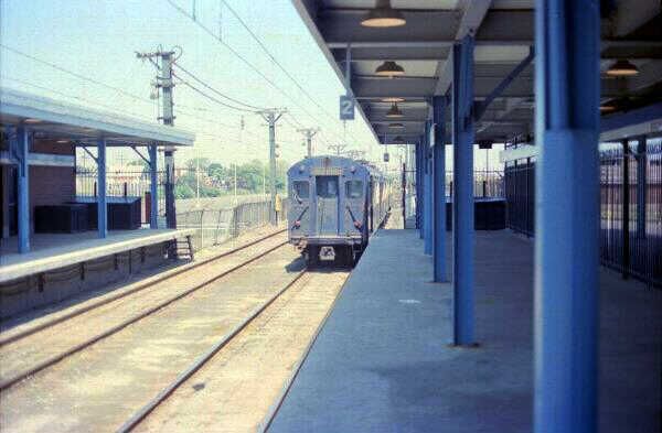 The Blue Line totals 5.9 miles (9.5 km),
with 2.1 miles (3.4 km) underground, and
12 stations. End-to-end running time is 23
minutes, producing an average end-to-end
running speed of 15.4 mph.
The Blue Line totals 5.9 miles (9.5 km),
with 2.1 miles (3.4 km) underground, and
12 stations. End-to-end running time is 23
minutes, producing an average end-to-end
running speed of 15.4 mph. 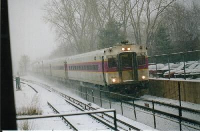 Out of North Station, routes run to
Rockport, Haverhill, Lowell, ipswich,
Fitchburg, and other destinations.
Southern and Western routes out of South
Station head for Plymouth, Kingston,
Middleboro, Stoughton, Providence,
Franklin, Worchester, Needham and other destinations. Many of
the routes are owned by the State of Massachusetts, but some
are owned by Guildford in the north and CSX and Amtrak in the
south.
Out of North Station, routes run to
Rockport, Haverhill, Lowell, ipswich,
Fitchburg, and other destinations.
Southern and Western routes out of South
Station head for Plymouth, Kingston,
Middleboro, Stoughton, Providence,
Franklin, Worchester, Needham and other destinations. Many of
the routes are owned by the State of Massachusetts, but some
are owned by Guildford in the north and CSX and Amtrak in the
south.