Light Rail Now and Walkable Neighborhoods (LRN) can be contacted at: Light Rail Now! |
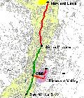
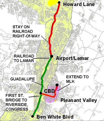
Austin: Public Meetings Consider Routes, Costs Special Report by Light Rail Progress Capital Metro recently held a series of information Sharing Meetings, focused on the recently presented route and cost options for the proposed light rail transit (LRT)/Bus Rapid Transit (BRT) system. During these meetings, which took place 21 August through 29 August 2000, Metro personnel and consultants presented the technical analysis completed to date and got feedback from the community on perceptions on different options through the corridor. While question-and-answer exchanges took place during the meetings, Metro personnel managed to keep the discussion focused on the specific issues on the table. All this information has been forwarded the Board as a resource for their expression of preference, in a board meeting scheduled for September 18. A number of LRT supporters attended these meetings and provided input on these route and cost issues. Light Rail Progress continues to urge LRT proponents to support a basic route plan which optimizes engineering, cost, and ridership for the initial startup system (see figure above). This route plan includes: Surface alignments throughout, rather than any of the
elevated (or subsurface) options. Cost must be minimized to facilitate eventual extension of
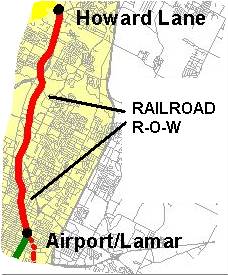
the system, promoting access and connectivity. A surface LRT alignment from Howard Lane to N. Lamar which stays on the railroad right-of-way (ROW). This is by far the lowest-cost, most direct, and fastest route
for this portion of the corridor. it has the greatest ridership
potential at the least cost. Minimizing installation cost will
free money for further and faster expansion of the LRT
system. A direct surface route from the railroad ROW onto Lamar and south. The preferred route (6E) through the UT/core area to downtown, using a double-track installation on Guadalupe to Cesar Chavez (formerly W. 1st). This is by far the least-cost option for this comparatively
expensive portion of the system. it is reasonably close to
Congress and the downtown center. it is direct and mostly
straight, solves a number of engineering problems, and
avoids the problem of service interruptions during parades
on Congress. The Guadalupe route would also serve the
new high-tech complex being installed in that part of lower
downtown. First Street (Drake) Bridge to South Austin. Riverside to S. Congress, and south. This would serve important development in this area and provide a connection to S. Congress with relatively minimal engineering and operational problems. The S. Congress route, using the existing very wide avenue, would be ideal for relatively fast, street-routed LRT in a segregated reservation. East Austin rail ROW alignment (9B) to Martin Luther King (formerly E. 9th St.). While this option adds about $34 million to the system cost,
this is a 1.3-mile extension rather than a more expensive
type of construction. The extension is desired by many East
Austin residents, and it would facilitate access to jobs and
other activities by a section of the population with higher
average unemployment and greater dependency on transit. Additional information on proposed routes, costs, etc. is also posted on the Capital Metro website: http://www.capmetro.org/index.html Light Rail Progress – Rev. 00/08/30 Support light rail for Austin! |
|
|
|
 Service to UT's
Pickle research complex can later be provided by a westerly branch, perhaps following Braker Lane to the Arboretum area and north on Jollyville Road. A surface routing on the rail ROW through the Wooten/Crestview neighborhoods would provide high-quality transit service to this area at the least cost. Neighborhood opposition to such an alignment appears to have the
character of hysteria and flows from concerns with little to no
basis in fact. Bypassing these neighborhoods would not
defuse much of this opposition, and yet would be a
disservice to the transit service level and ridership and to the
Austin community as a whole.
Service to UT's
Pickle research complex can later be provided by a westerly branch, perhaps following Braker Lane to the Arboretum area and north on Jollyville Road. A surface routing on the rail ROW through the Wooten/Crestview neighborhoods would provide high-quality transit service to this area at the least cost. Neighborhood opposition to such an alignment appears to have the
character of hysteria and flows from concerns with little to no
basis in fact. Bypassing these neighborhoods would not
defuse much of this opposition, and yet would be a
disservice to the transit service level and ridership and to the
Austin community as a whole.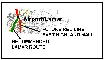 While a "dogleg"
over to Highland Mall and then back over to Lamar would access that major retail center, the ridership thereby gained might well be more than offset by
ridership lost due to the increased time and tediously
tortuous alignment. Despite the apparent preference for
such a dogleg by (unspecified) "peer" reviewers cited by the
consultants, commuters from north and northwest Austin
into the core area probably do not want time-consuming
diversions off the direct route. As someone has put it
succinctly, "You don't want to go all around the moon to get
where you're going." Whether designed as an elevated or
surface alignment, this dogleg appears to be more costly.
Moreover, it raises other issues, such as the problem of
attentuating wheel-squeal noise due to sharp turning
movements and possible opposition from the affected
residential neighborhoods. Service to Highland Mall can
eventually be provided by the Red Line, looping through
East Austin and through the Mueller redevelopment area,
then parallel to Airport Blvd. and past Highland Mall.
While a "dogleg"
over to Highland Mall and then back over to Lamar would access that major retail center, the ridership thereby gained might well be more than offset by
ridership lost due to the increased time and tediously
tortuous alignment. Despite the apparent preference for
such a dogleg by (unspecified) "peer" reviewers cited by the
consultants, commuters from north and northwest Austin
into the core area probably do not want time-consuming
diversions off the direct route. As someone has put it
succinctly, "You don't want to go all around the moon to get
where you're going." Whether designed as an elevated or
surface alignment, this dogleg appears to be more costly.
Moreover, it raises other issues, such as the problem of
attentuating wheel-squeal noise due to sharp turning
movements and possible opposition from the affected
residential neighborhoods. Service to Highland Mall can
eventually be provided by the Red Line, looping through
East Austin and through the Mueller redevelopment area,
then parallel to Airport Blvd. and past Highland Mall.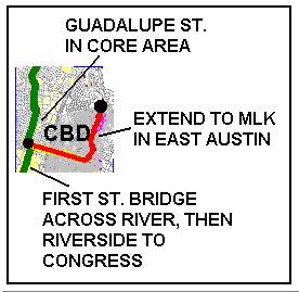 Consultants are optimistic that this relatively wide bridge can be cantilevered to support interurban-type LRT. This alignment would be relatively straight, in line with the Guadalupe route, and would provide service to a variety of new development being planned in the S. 1st/Riverside area.