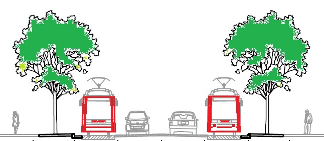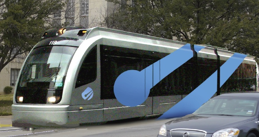
Austin LRT simulation (Simulation: COA/LRN)
Light Rail Now can be contacted at: Light Rail Now |
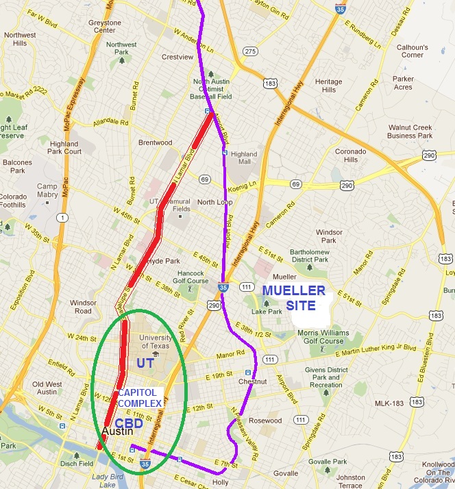
Lyndon Henry (Technical Conmsultant, Light Rail Now Project) • March 2012 Consider these two facts. A city's central, primary, and most congested local traffic corridor has been maxxed out at maximum capacity for more than the past two decades. Pointing to this critical problem, the city government proposes to invest approximately $1.4 billion in a rail transit system to "relieve congestion". So you'd think the $1.4 billion rail transit system would be routed to serve this critically congested corridor, right? Well, if the city is Austin, Texas — wrong. Austin's heavily congested inner-city local corridor is in one place, but the City of Austin's Urban Rail plan puts its heavy, pricey rail investment ... somewhere else. Missing the congested corridor entirely. Geography of central Austin To adequately understand this curious situation, it helps (particularly if you're not a native Austinite) to understand a bit of the geography of central-city Austin. Hopefully, the map below, focusing on downtown Austin at the bottom (south) to what's known locally as North Austin at the top, will be useful.
In this map, Austin's central business district (CBD) can be seen nestled up in the lower left against the Colorado River, now renamed Lady Bird Lake. Just north of the CBD is the Capitol Complex (the state capitol building and a cluster of state offices), and just north of that is the University of Texas (UT), with about 50,000 students and 16,500 faulty and staff. One should also note that the West Campus — that area on the west (left) side of the UT campus — has extraordinarily high population density, the fourth highest of any city neighborhoods in Texas (the others are in Dallas and Houston). These three major activity centers form what's historically been called the Core Area — roughly demarcated in this map by a green oval. Along the eastern edge of this area runs Interstate 35. Way over to the west (left) is the Loop 1 freeway (also called MoPac after the Missouri Pacific Railroad that eventually provided much of its right-of-way — and in the alignment of which the Union Pacific Railroad's main line still operates today). The thick red line, running from the Core Area north, follows that heavy major congested corridor mentioned above — the Lamar-Guadalupe corridor. Comprising this corridor, Guadalupe St. is a major arterial from about 45 St. down into the CBD. Just north of 45 St., there's a merge into Austin's other heavy-traffic inner-city arterial — Lamar Blvd. In this map, the red corridor line terminates at a diagonal purple line that marks Airport Blvd. The corridor itself actually continues north several more miles, but the portion from that point into the CBD is particularly relevant to Austin's historic rail transit planning, and today's Urban Rail proposal. MetroRail light railway That purple line marks the route of MetroRail (also called the Red Line), a diesel-powered light passenger railway that Capital Metro — the Austin area's regional transit authority — opened in 2010. MetroRail runs 32 miles from the lower eastern edge of Austin's CBD up to a northwestern exurb named Leander. Running with a fleet of just 6 railcars in an existing rail corridor, it was implemented as a bare-bones "starter" rail system, costing about $120 million (less than $4 million a mile, a bargain for a modern major transit investment). Each car is called a diesel multiple unit (DMU) — meaning it can be coupled with others and run as a train of self-powered cars.
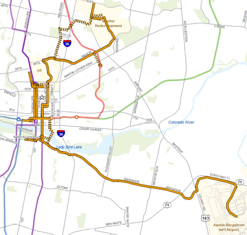
MetroRail was originally envisioned as a relatively low-cost "demonstration" line to show the Austin-area public what rail transit was really like, and to give a small taste of what this kind of transit alternative could achieve. The MetroRail concept was originally proposed on the 1980s by this author and Dave Dobbs, publisher of Light Rail Now. Today, it carries ridership of under 2,000 a day — small in comparison to many other rail systems, like those in Dallas and Houston ... but that number represents about 1,800 private motor vehicle trips diverted onto rail, vehicles that would otherwise be clogging inner-city freeways, arterials, and streets and competing for scarce parking. This small-scale DMU "demonstration project" also substituted for the much more ambitious electric light rail transit (LRT) project (also originally conceived and proposed by this author) that would have followed the Lamar-Guadalupe corridor — that thick red line — straight into the CBD. At the point where it intersects the Capital Metro railway, the purple line (that's where today's MetroRail Crestview station is located), it would have turned off Lamar to run on the rail alignment northwesterly, part of the way to Leander. According to Texas law, Capital Metro's major rail expansion plans must be approved by local voters, and in the November 2000 election, the LRT plan lost very narrowly — roughly 49.4% Yes, 50.6% No — with a margin of less than 2,000 votes. A majority of Austin city voters approved the project, and nearly 56% of all voters within a half-mile of the proposed routes approved ... but still, it lost (just a wee bit short on total service area votes). Eventually, Capital Metro focused on the simpler MetroRail plan, and that was approved by over 60% of voters in November 2004. While it's a more spartan, cheaper system, it also has some major drawbacks. First, being non-electrified, it's dependent on less efficient and ultimately more expensive diesel-propelled trains. This also means slower, somewhat more polluted operation than electric LRT. However, MetroRail does reduce traffic (and demand for Core Area parking spaces) a bit, so it still has a net benefit. The really big problem can be seen on the map — as MetroRail, in a broad "dogleg", totally bypasses almost all of the Core Area. Following an old Southern Pacific branch line, the route misses the well-developed commercial corridor along North Lamar and Guadalupe, and, traveling through East Austin, misses the UT campus, misses the Capitol Complex, and misses most of the CBD, before turning westward to end in the southeastern corner of downtown ... thus failing to serve almost all that heavy traffic flowing into the Core Area. In an effort to connect riders with other important Core Area destinations — like UT and the Capitol area — Capital Metro instituted special Connector bus services. But that's proved excessively expensive, and only one Connector now remains (serving only the east side of the campus, to boot). City of Austin's Urban Rail plan To try to link up more activity centers and residential neighborhoods within the Core Area, for several years the City of Austin (COA) has been developing its own Urban Rail plan (see map, below). Besides routes within and through the Core Area, there's a long route southeast to the new Austin-Bergstrom International Airport (ABIA), and a route northeast to the former Mueller Airport site, now an urban redevelopment area. All told, about 16.5 miles of LRT route are in the plan.
For rolling stock, the original Urban Rail plan envisioned streetcars (a smaller, slower form of LRT), but more recent plans are proposing a shorter version of a faster, full-performance LRT type of car, such as the new Siemens S-70 cars running in San Diego. In effect, except for the route, it represents a return to the original LRT concept of the 2000 plan.
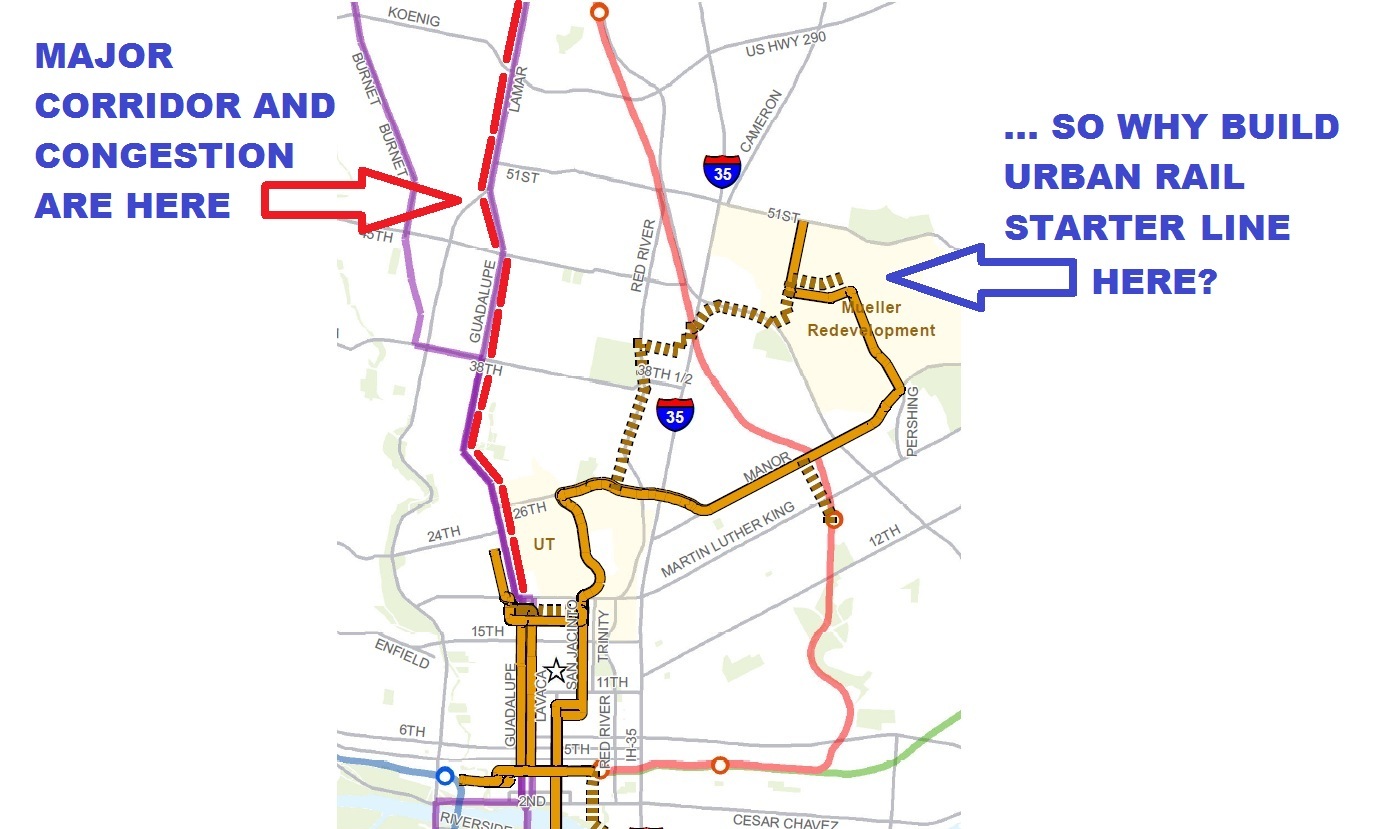
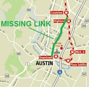
At first, the COA plan, despite some very serious drawbacks, looked like a good start. City planners assured Austin community transportation activists the plan wasn't" "set in stone". Except that ... it was "set in stone" ... flaws and all. A small "Transit Circle" of Austin professionals, transportation planners, and public transportation activists is now challenging the plan with serious criticisms. (Yet another disclosure: This author is one of these critics.) The plan, they say, as currently proposed, has three major route problems: • It totally misses the Lamar-Guadalupe corridor — now referred to as the "Missing Link". Instead, that meandering northeastern line is planned to serve the Mueller redevelopment site. Problem: The Mueller site has relatively little current activity, and no perceptible traffic congestion. The heavy activity, traffic, and congestion, are all over on the Lamar-Guadalupe corridor — the Missing Link. COA's currently favored proposal for Urban Rail to reach Mueller from UT poses additional problems. It would route the LRT line up a very constrained eastside street, Red River, squeezed into neighborhoods, then carry it through an existing shopping mall (Hancock Center), across the MetroRail (Red Line) tracks, into Airport Blvd., and then westerly into the Mueller site. To implement this convoluted, complicated route seems to promise low speeds, extra traffic problems, engineering difficulties, and very high cost — for very little payoff.• The COA plan's major trunk route through the UT campus goes up the east side (San Jacinto St.), rather than the west side of campus — totally avoiding the busy commercial corridor on the "Drag" (Guadalupe) and that ultra-dense West Campus area. (Responding slightly to these criticisms, planners have included a short, stub branch of Urban Rail on one of the minor streets of the West Campus.) • The line going southeast to the airport, serving the busy commercialized, well-populated Riverside Drive corridor along the way, is certainly the most viable and sensible component of the COA plan. But, while the Riverside-ABIA line would be a "Nice To Have", it's far from serving from the city's busiest, most congested corridor. It would also be fairly expensive to install, mainly because of the need to cross the river (Lady Bird Lake) and to negotiate the freeways and expressways into the ABIA airport. Curiously, COA planners repeatedly brandish the terrible congestion in the Lamar-Guadalupe (Missing Link) corridor. In the spring of 2011, COA planners, in meetings mandated by the federal National Environmental Policy Act, repeatedly emphasized that the corridor's capacity has been maxxed out for over two decades. But they then continue to advocate a plan that totally avoids any rail service to this corridor. (Instead, Capital Metro is implementing a so-called "rapid bus" plan — basically, limited-stop buses, operating mostly in mixed traffic with special, spiffy, state-of-the-art stations — due to open in 2014.) This policy contradiction is illustrated in the graphic below (included in a recent presentation to Austin's official Transit Working Group, or TWG). .
Technology integration of Urban Rail, MetroRail Besides route weaknesses, another problem identified by critics is the need for a technological integration of the two rail systems — Urban Rail and MetroRail — on the basis of electric LRT. Splitting up rail development between COA's Urban Rail and Capital Metro's MetroRail, they argue, is inefficient, wasteful, and reckless with taxpayer dollars. Instead, integrating the two rail technologies, they contend, would yield a number of other advantages — such as improved performance, environmental benefits, and the cost advantages of electric propulsion. Plus it would enable some economies of scale, in procuring both infrastructure materials and rolling stock. As for the current MetroRail DMUs, according to this proposal, they could be deployed for service to more outlying service where extension of electrification would be less cost-effective. Technological integration, with electrification, would solve several problems, according to this argument. For example, it would facilitate procurement of far more standardized, widely available, lower-cost rolling stock, and would facilitate a seamless east-west connection through the CBD. With inter-lining of routes, say pro-LRT critics, integration would solve numerous logistical problems, such as creating links between the northern MetroRail alignment and the Core Area, and a seamless crosstown connection between MetroRail's current terminus at Austin's Convention Center and a major development area on the west side (known as Seaholm) and the city's Amtrak station. Technical integration would also facilitate a connection between the main UT campus and UT's Pickle Campus, located to the northwest, about a half-mile from the MetroRail line — thus solving one of UT's most difficult mobility needs. Adding Missing Link to Urban Rail Since Lamar-Guadalupe is the primary local traffic corridor in central-city Austin, pro-rail critics argue, any truly adequate and justifiable rail transit investment must serve this crucial Missing Link. In this view, Austin's limited resources must be invested to yield the maximum ridership — initially, that would mean a rail connection between the Crestview Red Line MetroRail station, the West Campus, and downtown.
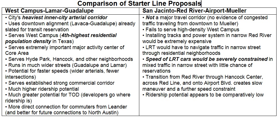
In addition to serving this very heavy corridor, say pro-rail critics of the COA plan, implementing the "Missing Link" would add direct rail service between the northwest suburbs and close-in neighborhoods like Hyde Park and Hancock, the Triangle, the UT campus, the dense West Campus area, the Capitol Complex, and downtown; provide UT with the critical connection it needs between the main central campus and the Pickle campus; eliminate the need for costly dedicated Connector bus service for MetroRail; and enable more cost-effective use of the current MetroRail DMU rolling stock (by shifting them to outlying service corridors). Moreover, according to this view, installing electric LRT service in this major corridor has the potential of increasing total rail system ridership dramatically. A recent presentation to the TWG compared the original 2000 LRT plan with the COA's deficient Urban Rail plan: In the original plan, a single LRT line, 14.6 miles long, from the vicinity of McNeil Rd. (north of the central city, on today's MetroRail alignment) to downtown (using the Capital Metro railway, then Lamar and Guadalupe) was projected to carry 32,100 daily trips in its first year. COA's entire, 5-route Urban Rail system, 16.5 miles, is projected to carry just 27,600 trips in 2030. Why, the presentation asked, spend the nearly $2 billion (about 80% more than the inflation-adjusted cost of the 2000 LRT plan) to get less? The table in the graphic below compares the West Campus-Lamar Guadalupe route plan proposed by pro-rail advocates with COA's East Campus-Red River-Mueller plan officially on the table.
Austin needs a sensible rail plan Austin, a very fast-growing urban area, has long been in need of an adequate rail transit system to ensure sufficient mobility and livable neighborhoods as it moves into the future. But resources are obviously limited, and need to be prioritized to produce optimal benefits — especially to maximize ridership as well as the benefit-cost ratio of any proposed project.
Basically, argue pro-rail advocates, Urban Rail lines serving both the Mueller site and the Riverside corridor to ABIA would both be "Nice to Haves". But the Missing Link — a connection from Capital Metro's railway down the key Lamar-Guadalupe corridor — would be essential to have. Furthermore, technological integration of both rail systems would be a prudent and cost-effective use of limited tax dollars. And that, say critics, is where Austin's major Urban Rail plans and priorities should be focused. Light Rail Now! website |
||||
|
|
|||||

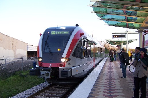 MetroRail train at Crestview station.