Related Links
Light Rail Progress can be contacted at:
Light Rail Progress
lightrailnow@lightrailnow.org
 |
 Cincinnati's Rail + Bus Plan = Lower Mobility Cost, Higher Quality of Life
By Light Rail Progress • October 2002
NOTE: in the election of 5 November 2002, the Cincinnati MetroMoves proposal, issue 7, failed to pass.
Expanding mobility options ... reducing mobility costs per capita ...improving urban quality of life – those are the potential rewards in
store for Cincinnati-area residents if they approve the MetroMoves
public transit ballot measure in November 2002. Proposed by the
Southwest Ohio Regional Transit Authority, the plan asks
Hamilton County voters to approve a half-cent sales and use tax
to be used to expand Cincinnati's currently excellent bus system
(called Metro) across the entire county, to upgrade overall service,
and to build a network of light rail transit (LRT) – both interurban-suburban trains and urban streetcars – and regional ("commuter")
rail.
 The plan is ... well, pretty breathtaking. The bus service
improvements alone are enough to make most other US cities envious.
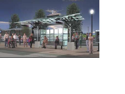
A central feature of the plan is a reorganization of the whole system around "transit hubs" – where
buses, shuttles, streetcars, and/or light rail come together, so people can easily, safely, and conveniently transfer from one route to
another. About 30 of these hubs, located throughout the Cincinnati region, would help create a network of interconnecting transit services (see bus system map below). The plan is ... well, pretty breathtaking. The bus service
improvements alone are enough to make most other US cities envious.
A central feature of the plan is a reorganization of the whole system around "transit hubs" – where
buses, shuttles, streetcars, and/or light rail come together, so people can easily, safely, and conveniently transfer from one route to
another. About 30 of these hubs, located throughout the Cincinnati region, would help create a network of interconnecting transit services (see bus system map below).
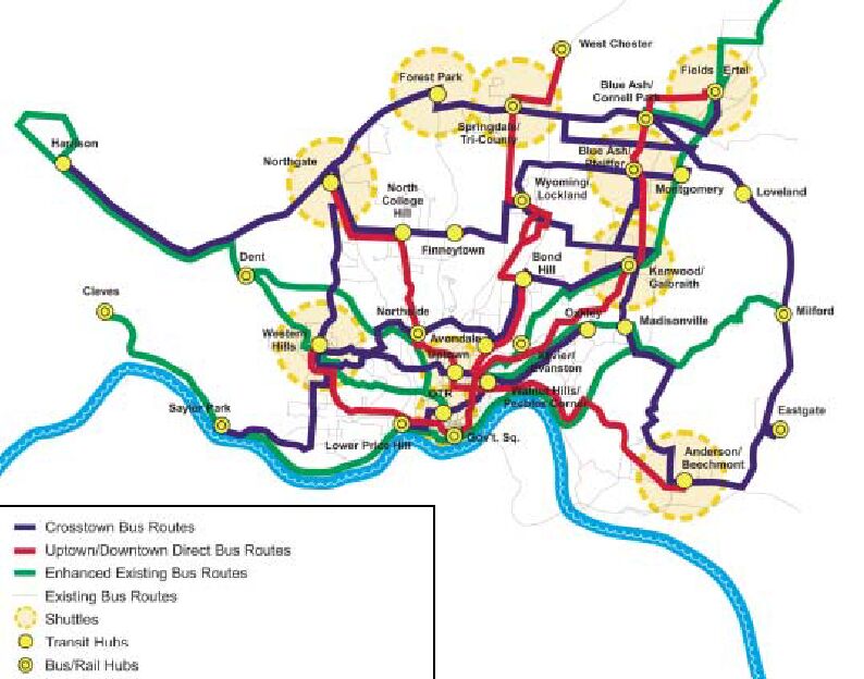
New east-west, crosstown, and cross-regional bus routes would
intersect with existing and new north-south Metro routes. This "hub-to-hub" bus service would mean that riders would have no
need to go downtown just to transfer. New weekday express bus routes would link the new suburban transit hubs with downtown.
New weekday routes would link suburban communities with the University of Cincinnati and most major hospitals in the city's
uptown area. And smaller neighborhood shuttle buses would connect neighborhood-based jobs, shopping, housing, and entertainment with transit hubs.
That's a fairly impressive grid of bus service. But it just provides
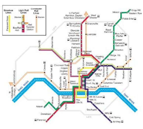
the fabric of connectivity for the extensive system of rail transit lines crisscrossing the region which provide the capacity, speed,
and attractive level of service needed to move many thousands of Cincinnatians quickly, efficiently, and cost-effectively (see rail map, below).
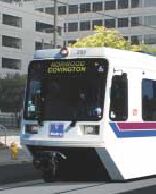
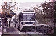 All in all, sixty miles of interurban-suburban
LRT services are planned in a number of routes (see photo from San Jose LRT, right): All in all, sixty miles of interurban-suburban
LRT services are planned in a number of routes (see photo from San Jose LRT, right):
- I-71 "Green Line" light rail, airport to
downtown to Kings island
- I-75 "Red Line" light rail, Florence to downtown to West Chester
- Eastside "Blue Line" light rail*, downtown to Xavier to Eastgate
- Westside "Purple Line" light rail, downtown via I-74 to Dent
- Crosstown "Light Green Line" light rail, Dent/Rybolt Rd. to Xavier to Eastgate
- I-471 "Blue Line" light rail, downtown to Northern Kentucky
University and AA Highway
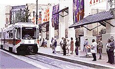
Urban LRT electric streetcars (yellow lines on the map below)
would provide reliable, high-visibility connections between central-city neighborhoods (see photo of Portland, Oregon streetcar at right):
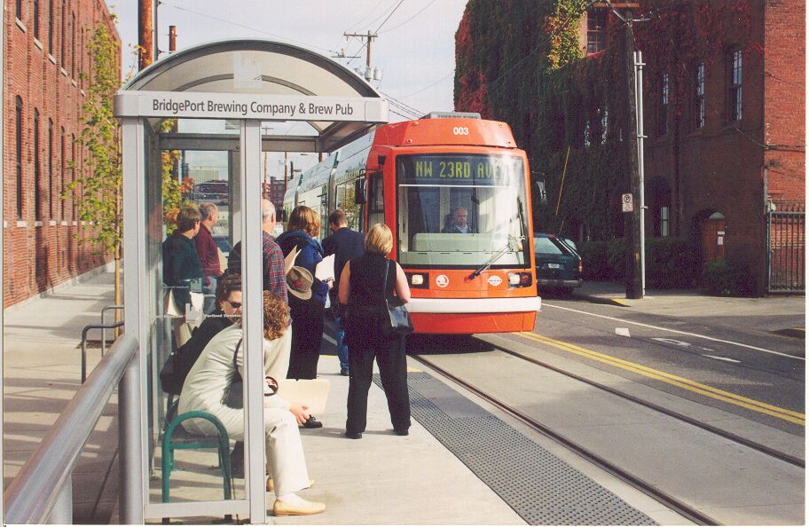 Uptown streetcar line, running from the downtown area, along Vine Street through Over-the-Rhine to the University of Cincinnati and Mount Auburn, connecting all of these areas and the city's hospital district Uptown streetcar line, running from the downtown area, along Vine Street through Over-the-Rhine to the University of Cincinnati and Mount Auburn, connecting all of these areas and the city's hospital district
- Riverfront streetcar, connecting Cincinnati and the Northern Kentucky riverfront communities of Covington and Newport
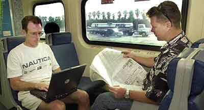 And, to provide higher-speed regional
transit connectivity, an extensive regional ("commuter") passenger rail system would be installed (open orange lines on the map
below; also see photo of Miami Tri-Rail passengers at left): And, to provide higher-speed regional
transit connectivity, an extensive regional ("commuter") passenger rail system would be installed (open orange lines on the map
below; also see photo of Miami Tri-Rail passengers at left):
Cincinnati-Dayton commuter rail, with stops in Fairfield and Hamilton, and future highspeed service to Columbus and Cleveland (Ohio rail initiative)
Cincinnati-Lawrenceburg commuter rail, with future highspeed service to indianapolis, Chicago (Midwest rail initiative)
Cincinnati-Milford commuter rail
Local cost of the LRT plan is projected at $2.6 billion (total bus
and rail system cost, including the federal share, is over $4.0 billion). The plan calls for the rail system to be built over 30 years,
with a line connecting downtown to Blue Ash along I-71 to be built first.
That expense must be weighed against the extensive benefits:
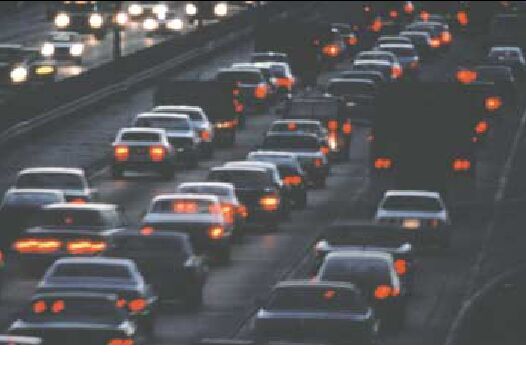
- The MetroMoves plan will reduce the cost of mobility in the
Cincinnati region, saving Cincinnatians bankloads of money in the
long run, and freeing up consumer purchasing power for other
things. Overall, automobile transportation is expensive (see Cost per Passenger-Mile of an Urban Automobile). Riding the bus is
cheaper, but buses are relatively expensive to operate. LRT,
streetcars, and regional rail tend to lower the cost of public transit
service per passenger-mile because they attract more passengers
than buses and carry them more economically (see How Light Rail Saves Operating Cost Dollars Compared With Buses and
Light Rail Lowers Operating Costs). In Dallas, for example, the
LRT system installed in 1996 has dropped the cost per
passenger-mile by 38%, compared with buses. The American
Public Transportation Association reports that for every dollar
invested in light rail there will be a $6 dollar return to taxpayers.
- Rail transit will take some of the pressure off the roadway system,
providing alternative mobility options for commuters, and enabling
highway dollars to be spent more efficiently. Studies show that,
because additional highway capacity "induces", or generates,
totally new motor-vehicle traffic, highway builders have to provide
4 new lanes just to get one, single lane of real additional capacity!
Rail transit does not induce new road traffic, and, by attracting
motorists, actually takes cars off the road – and out of competition
for scarce parking spaces.
 Traffic congestion in Cincinnati seems to be growing faster than population, and even faster than road capacity is being added.
According to the latest (2002) Mobility Report from the Texas Transportation institute, between
1985-2000, Cincinnati's urban area population increased about 14%, while total roadway mileage surged 45% and freeway lane-mileage grew by 20%. Yet traffic congestion – measured by the
study's Travel Time index – increased 19%. Public transit –
particularly rail transit – would give Cincinnatians an additional,
highly attractive choice for avoiding that congestion for some or all
of their daily trips. Rail transit provides an attractive, workable,
low-cost, safe alternative to the "traffic battleground" – the
struggle for road space and parking spaces. it means a safer,
more reliable alternative to the stress and danger of the "traffic
meatgrinder", the de facto battle with congestion, Road Warriors,
and Road Ragers. This may not "work" for everybody all the time,
but it will meet the needs of many family members much of the time – and it will be there when you need it. Traffic congestion in Cincinnati seems to be growing faster than population, and even faster than road capacity is being added.
According to the latest (2002) Mobility Report from the Texas Transportation institute, between
1985-2000, Cincinnati's urban area population increased about 14%, while total roadway mileage surged 45% and freeway lane-mileage grew by 20%. Yet traffic congestion – measured by the
study's Travel Time index – increased 19%. Public transit –
particularly rail transit – would give Cincinnatians an additional,
highly attractive choice for avoiding that congestion for some or all
of their daily trips. Rail transit provides an attractive, workable,
low-cost, safe alternative to the "traffic battleground" – the
struggle for road space and parking spaces. it means a safer,
more reliable alternative to the stress and danger of the "traffic
meatgrinder", the de facto battle with congestion, Road Warriors,
and Road Ragers. This may not "work" for everybody all the time,
but it will meet the needs of many family members much of the time – and it will be there when you need it.
- The MetroMoves plan would bring a significant improvement in
Cincinnati's urban quality of life. In city after city where light rail
has been installed, neighborhood integrity has been preserved while urban livability has increased. Furthermore, small
businesses along every light rail line have prospered tremendously, as LRT has brought far more exposure and
customers than come by automobile. From Howard St. In Baltimore, to Pacific Ave. In Dallas, to First Ave., Morrison, and
Yamhill St. In Portland, the evidence demonstrates that LRT helps small businesses thrive.
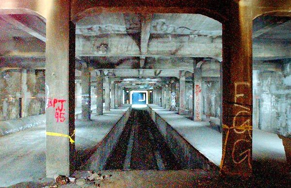 The MetroMoves plan would at last
make effective use of Cincinnati's existing but never-used subway – 2.2 miles of concrete tubes
excavated and paid for by Cincinnati taxpayers in the 1920s and 1930s, but never used. The existing subway would not only
enable engineers to easily connect the east side to the west side of the proposed system – facilitating a true countywide plan – but also the tunnels are expected to be worth hundreds of millions of dollars in savings (in terms of "in kind" local match for federal dollars) if the project is approved by the Federal Transit Administration. The MetroMoves plan would at last
make effective use of Cincinnati's existing but never-used subway – 2.2 miles of concrete tubes
excavated and paid for by Cincinnati taxpayers in the 1920s and 1930s, but never used. The existing subway would not only
enable engineers to easily connect the east side to the west side of the proposed system – facilitating a true countywide plan – but also the tunnels are expected to be worth hundreds of millions of dollars in savings (in terms of "in kind" local match for federal dollars) if the project is approved by the Federal Transit Administration.
- Because the infrastructure for rail transit is essentially permanent,
rail stimulates economic development in terms of housing, retail, and business activity around rail hubs. In city after city, LRT has
solidly demonstrated its potential for stimulating and shaping adjacent real estate development at its transit stops and stations.
This process both builds in ridership (e.g., trips by people living near the stations or traveling to the nearby activity centers) and
raises the tax base (by increasing land and property values).
Together with effective policies to manage traffic and guide land use, transit-shaped development can be a key tool in helping to
contain urban sprawl. In Dallas, more than $800 million in private funds has been invested in development along DART's 20-mile
Light Rail Starter System - an explosion of adjacent real estate development which materialized less than 4 years after LRT was installed.
 Particularly where LRT uses existing street
right-of-way, mobility and urban livability are improved. The person-moving
capability of the corridor is increased – not just its vehicle-moving capacity. LRT
introduces a "traffic-calming" effect, interfacing well with pedestrians and cyclists, and making urban
streets far more human-scale and "livable". Throughout Europe, and in more and more American cities, surface LRT trains blithely
coast by adjacent traffic, and glide thorough downtown streets, past pedestrians on wide sidewalks, past patrons in outdoor
restaurants and cafes, sitting next to the tracks. Particularly where LRT uses existing street
right-of-way, mobility and urban livability are improved. The person-moving
capability of the corridor is increased – not just its vehicle-moving capacity. LRT
introduces a "traffic-calming" effect, interfacing well with pedestrians and cyclists, and making urban
streets far more human-scale and "livable". Throughout Europe, and in more and more American cities, surface LRT trains blithely
coast by adjacent traffic, and glide thorough downtown streets, past pedestrians on wide sidewalks, past patrons in outdoor
restaurants and cafes, sitting next to the tracks.
With such a multitude of proven benefits, it would seem like the
decision to implement such a program of mobility and quality-of-life improvements would be a no-brainer. But it will be an uphill
struggle, especially as the plan asks Cincinnatians to approve a new tax for transportation modes most have never seen or
experienced. Will a majority of Hamilton County voters be willing to take a chance on a very different mobility direction and a major
change in the character of their city? We'll have to wait till November 5th for the answer to that.
Rev. 2002/10/14
More on Planning for Rail Transit in Cincinnati
|