An Aerial Photo Tale of Two Cities
There is a lot of debate over the relative benefits and drawbacks of American cities with well-developed rail transit and those that have depended on bus transit alone while emphasizing highway development. One of the most significant differences is represented by land use and urban development patterns.
Aerial photography provides a useful way to grasp this difference. While it hasn't been easy to find suitable aerial photos of two contrasting cities in the right perspective and same scale, photos of two such cities seem to provide appropriate examples. The contrast of aerial views of San Francisco vs. Cincinnati provides an opportunity for the striking visual comparison being sought – a picture is indeed worth a thousand words.
To show development patterns in a mature rail transit city, San Francisco (with its downtown waterfront on the San Francisco Bay) offers an example of a city with no downtown interstates, that has instead operated heavy rapid transit, light rail, and regional ("commuter") rail for many decades – with modern rail for more than 30 years.
For an all-bus city with extensive urban expressways but no rail service, Cincinnati provides a similar view of a downtown along a waterfront (the Ohio River) – in this case, "enhanced" by the "beloved" I-71 and I-75 freeways.
Aerial Photo Comparison: San Francisco vs. Cincinnati
San Francisco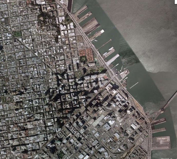 in this view of downtown San Francisco and its waterfront, unseen is the "heavy" rapid rail BART subway system, the Muni Metro light rail system (also underground in the downtown). Just out of the photo to the south is the CalTrain regional (commuter) rail station, and on the surface and visible in the photo is a surface light rail line and a streetcar line, along with cable cars, electric trolleybuses, and diesel buses. [Photo: Google Maps] |
Cincinnati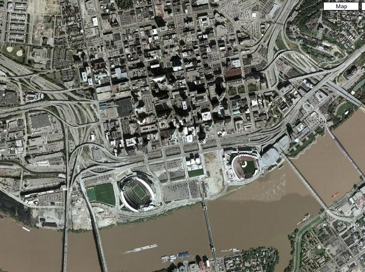 in this photo of downtown Cincinnati and its waterfront, besides the great swaths of concrete of the roadways themselves are the vast parking lots and garages necessary to accommodate the battalions of private motor vehicles which this combined land use and transportation policy is designed to encourage. [Photo: Google Maps] |
Clearly, decisions interms of public transit vs. highways have much wider and longer-term implications for the way a city will eventually grow, and how it most valuable core area land will be used. And these elements in turn will undoubtedly have implications for the economic vitality of a given central city.
Some of the material in this photo-essay was originally posted to the Trolley Politics online discussion list.
Light Rail Now website